
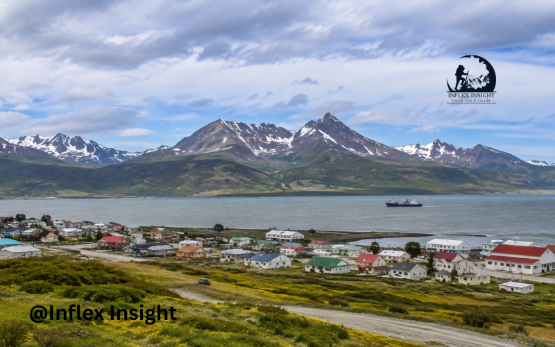
Puerto Williams Isla Navarino offers one of the most remote travel experiences in Chilean Patagonia. Puerto Williams is a small city on the northern coast of Isla Navarino, facing the Beagle Channel. The island lies in the far south of Chile, within the Tierra del Fuego archipelago and close to Cape Horn.
Travel here is very different from visiting a busy tourist destination. Transportation is limited, the weather can change quickly, and many activities involve wild outdoor settings. However, visitors are rewarded with dramatic mountains, quiet forests, coastal scenery, Indigenous history, and challenging trekking routes.
Puerto Williams and Isla Navarino at a Glance
Puerto Williams is the main settlement and service center on Isla Navarino. It belongs to Chile’s Magallanes and Chilean Antarctic Region and is often described as one of the southernmost cities in the world.
The community has only a few thousand residents, giving it a quiet and personal atmosphere. Its setting combines subantarctic forests, peatlands, rocky mountains, lakes, bays, and views across the Beagle Channel toward Argentine Tierra del Fuego.
Although basic services are available, visitors should not expect the wide range of shops, transportation, and accommodation found in larger Patagonian destinations. Careful planning is important, especially for independent hikers.
Why Puerto Williams Isla Navarino Is Worth Visiting
The main appeal of Puerto Williams Isla Navarino is its sense of isolation. The landscape feels open, peaceful, and largely untouched by mass tourism. Visitors can walk along the waterfront, climb to mountain viewpoints, explore native forests, and learn about a community shaped by the sea and extreme southern weather.
The destination is particularly attractive to experienced hikers, photographers, birdwatchers, and travelers who enjoy quiet places. It may be less suitable for people seeking nightlife, luxury shopping, or a tightly packed sightseeing schedule.
A journey here is not only about reaching a distant location. It is also about slowing down and experiencing daily life near the southern edge of the Americas.
The Best Time to Visit Puerto Williams and Isla Navarino
The main travel season runs from roughly November through March. These months provide longer daylight hours and generally better conditions for hiking. December, January, and February are especially popular, but rain, strong winds, low temperatures, and even snow can still occur.
Spring and autumn are quieter, although colder conditions and shorter days can limit outdoor plans. Winter brings snow, ice, and very limited daylight, making it a specialized season rather than the easiest choice for a first visit.
For trekking, the warmer months usually provide the best opportunity. Even then, travelers should keep their schedule flexible because southern Patagonian weather can delay flights, ferries, tours, and hiking plans.
How to Get to Puerto Williams Isla Navarino
Most visitors first travel to Punta Arenas, which has regular air connections with Santiago. From Punta Arenas, the fastest option is a small-plane flight to Guardiamarina Zañartu Airport in Puerto Williams. The journey generally takes about one hour to one hour and fifteen minutes, although schedules and flight frequency can change. Seats are limited, so early booking is sensible. Chile Travel and DAP Airlines provide current route information.
A ferry also connects Punta Arenas and Puerto Williams. The sea journey takes approximately 30 to 33 hours and passes through remarkable Patagonian channels and fjord scenery. It is much slower than flying, but the voyage can become a memorable part of the trip. Current schedules should be checked directly with TABSA.
Connections from Ushuaia may operate through authorized boat services and Puerto Navarino, but they are not always regular or available throughout the year. Travelers crossing between Argentina and Chile must complete immigration requirements in both countries.
International visitors should check passport and visa rules for their nationality before departure. Chile does not require every nationality to obtain prior authorization, but some travelers must arrange a visa in advance. Chile’s National Migration Service provides official information.
Getting Around Isla Navarino
Puerto Williams is compact enough to explore on foot. Accommodation, restaurants, the waterfront, shops, and several local attractions are generally within a manageable area.
Travel outside the city requires more planning. Isla Navarino has limited roads, taxis, and private transfer services. Public transportation does not operate like it does in a large city. A taxi or prearranged vehicle may be needed to reach Puerto Navarino, Bahía Wulaia departure points, distant trailheads, or other remote areas.
Visitors should confirm both outward and return transportation before leaving town. Mobile service may be weak or unavailable outside populated areas.
Top Things to Do in Puerto Williams
A relaxed walk around Puerto Williams is a good introduction to the island. The waterfront provides views of the Beagle Channel, fishing boats, visiting yachts, and the mountains of Tierra del Fuego. The harbor and Micalvi yacht club area reflect the city’s close connection with sailing and maritime life.
The Museo Territorial Yagan Usi–Martín González Calderón is an important cultural stop. Its exhibitions focus on the Yagán people, local archaeology, regional history, and the natural environment. The museum was renamed and reopened with updated displays in 2024. Museos Chile describes it as the world’s southernmost museum.
Visitors can also enjoy local seafood, explore small viewpoints, or simply observe the quiet rhythm of everyday island life.
The Best Natural Attractions on Isla Navarino
Cerro Bandera is one of the most accessible natural attractions near Puerto Williams. Its viewpoint overlooks the city, the Beagle Channel, and surrounding mountains. Laguna del Salto lies deeper within the landscape and is an important point along the Dientes de Navarino route.
Omora Ethnobotanical Park protects native plants, birds, forests, and miniature ecosystems such as mosses and lichens. Visits may require advance coordination or a guided experience.
Farther west, Puerto Navarino offers a quieter coastal setting across from Ushuaia. Bahía Wulaia is known for its scenery and Yagán history, although reaching it normally involves an organized boat trip. The island’s coastal roads also provide peaceful views of forests, bays, and the Beagle Channel.
Hiking the Dientes de Navarino Circuit
The Dientes de Navarino Circuit is the island’s best-known adventure. The remote route covers approximately 40 to 50 kilometers, depending on the starting point and route variation. Most hikers need four to five days to complete it.
The trek crosses steep passes, loose rock, muddy peatland, exposed slopes, forests, and areas where trail markings may be difficult to follow. Important points include Laguna del Salto, Laguna de los Dientes, Paso Australia, and Paso Virginia. Weather can change quickly, even during summer.
This is not a beginner-friendly walking trail. Hikers need suitable camping equipment, waterproof clothing, reliable navigation tools, enough food, and experience in remote mountain conditions. Official guidance says trekkers must register their departure and return with Carabineros in Puerto Williams. Chile Travel describes the circuit as a highly demanding four- to five-day journey.
Easier Walks and Day Hikes Near Puerto Williams
Travelers do not need to complete the full Dientes circuit to enjoy Isla Navarino. Cerro Bandera is a popular medium-difficulty day hike, usually completed in around three hours, although timing depends on fitness and trail conditions. The viewpoint offers an excellent introduction to the island’s mountain scenery.
Shorter forest walks and sections near the Róbalo River provide alternatives for people with limited time. Some travelers hike toward Laguna del Salto and return rather than continuing around the circuit.
Yagán Culture and the Human History of Isla Navarino
The Yagán, also written as Yaghan, have lived in the southern channels of Chile and Argentina for thousands of years. Their traditional way of life was closely connected to the sea, canoes, fishing, gathering, hunting, and movement between islands.
Visitors can learn about this history at the Museo Territorial Yagan Usi and through respectful cultural experiences offered in the region. The museum’s permanent exhibition presents both archaeological history and the living Yagán community rather than treating the culture as something that exists only in the past.
Travelers should follow local guidance, avoid entering sensitive sites without permission, and use the names and stories of the community respectfully.
Wildlife and Landscapes Around Isla Navarino
Isla Navarino contains forests, peat bogs, mountain lakes, rocky coastlines, and exposed alpine areas. Birds are among the most visible animals, while marine journeys may offer opportunities to see seabirds and other coastal wildlife.
The island’s environment is beautiful but sensitive. Peatlands can be easily damaged, and leaving marked paths may increase erosion. Introduced beavers have also changed some forest and wetland areas.
Wildlife should be observed from a comfortable distance. Visitors should avoid feeding animals, disturbing nests, collecting plants, or using drones where they may affect wildlife or local privacy.
Where to Stay in Puerto Williams
Accommodation consists mainly of guesthouses, hostels, cabins, small hotels, and a limited number of higher-end properties. Many places are simple but warm and comfortable, which matters in the island’s cool climate.
Hikers may find basic camping or refugio-style options, but they should confirm facilities before relying on them. Wild camping on the Dientes circuit requires proper equipment and full self-sufficiency.
Availability can become limited during the summer trekking season. Booking early is especially important when flights and accommodation must match on specific dates.
Food, Supplies, and Essential Services
Puerto Williams has small restaurants, cafés, grocery stores, and places serving seafood and basic Chilean meals. King crab may be available, although menus and opening hours can vary with the season and local supply.
Travelers planning a multi-day trek should not assume that every specialist item will be available. Bring important medicines, navigation equipment, preferred hiking food, batteries, and difficult-to-replace gear from Punta Arenas.
Cash is useful because payment systems and internet connections may occasionally be unreliable. Medical care is available locally, but serious emergencies may require transfer to a larger regional center.
Planning a Puerto Williams Isla Navarino Itinerary
A two-day visit can include the waterfront, museum, local food, and a Cerro Bandera hike. Three or four days allow time for Omora Park, another day walk, and a possible coastal excursion.
Travelers completing the Dientes de Navarino Circuit should allow at least four to five trekking days, plus time before and after the hike. A longer stay also creates a safety margin if weather delays transportation.
Whenever possible, avoid arranging an important international connection immediately after leaving Isla Navarino. One or two flexible days can prevent a weather delay from disrupting the rest of the journey.
Budget and Travel Costs
Travel in Puerto Williams often costs more than travel in larger Chilean cities because transportation and supplies must reach a remote island. Flights, ferry tickets, private transfers, accommodation, guided activities, and trekking equipment will form the main expenses.
Guesthouses and self-catering can reduce daily costs, but the cheapest room may not always be available during summer. Guided Dientes trips are considerably more expensive than independent trekking because they may include guides, meals, tents, safety equipment, and logistics.
Rather than relying on fixed online estimates, request current prices directly. Fares and exchange rates can change, and services may operate differently by season.
Essential Packing List for Isla Navarino
Pack waterproof outer clothing, a windproof jacket, warm layers, gloves, a hat, sturdy hiking boots, sun protection, and a small daypack. Clothing should be layered because temperature and wind conditions can change within hours.
Remote trekkers also need a strong tent, a suitably warm sleeping bag, cooking equipment, food, navigation tools, a first-aid kit, and an emergency communication plan. Waterproof storage for documents and electronics is useful.
Safety and Responsible Travel
Weather is the main factor affecting safety on Isla Navarino. Check local forecasts, ask residents or guides about current trail conditions, and change plans when conditions become unsafe.
Remote hikers should share their route, carry navigation equipment, and complete the required registration with Carabineros. Rescue assistance may take time because of the island’s terrain and isolation.
Follow Leave No Trace principles by carrying out rubbish, using established campsites where available, and avoiding damage to vegetation. Respect private land, local residents, cultural sites, and wildlife. Careful preparation protects both the traveler and this sensitive southern environment.
Conclusion
Puerto Williams Isla Navarino combines remote Patagonian scenery, Yagán heritage, outdoor adventure, and quiet community life. It is not the easiest destination to reach, but careful planning makes the journey manageable.
Travelers should book transportation early, prepare for sudden weather changes, and choose activities that match their experience. Whether visiting for the Dientes circuit or a few peaceful days near the Beagle Channel, Isla Navarino offers a rare view of life at Chile’s wild southern edge.
FAQs
1. Is Puerto Williams located on Isla Navarino?
Yes. Puerto Williams is located on the northern coast of Isla Navarino in southern Chile. It faces the Beagle Channel and serves as the island’s main population, transportation, and service center.
2. How many days should you spend in Puerto Williams?
Three to four days is suitable for exploring the city, visiting cultural attractions, and completing one or two day hikes. Travelers attempting the Dientes de Navarino Circuit should plan at least a week, including preparation and extra time for weather delays.
3. Is the Dientes de Navarino trek suitable for beginners?
Generally, no. The circuit involves difficult navigation, steep mountain passes, mud, loose rock, camping, and rapidly changing weather. Beginners should build experience first or complete the trek with a qualified local guide.
4. Can you visit Isla Navarino without completing a long trek?
Yes. Visitors can explore Puerto Williams, visit the Yagán museum, walk along the waterfront, hike Cerro Bandera, discover local food, and arrange cultural or nature excursions without completing a multi-day trek.